Doe Bridge Association Meeting

The Doe Bridge Association met on Sunday, March 4th, and welcomed a new face, George Allen Adkins. Dan Parsons, Sussex County Historic Preservation Planner, was also in attendance. He is interested in helping us and will call later in the week, to arrange a visit to both sites.

A gallery of photos from the Atwood Timmons 1955-1980 collection was presented and those images from Millsboro’s past brought back lots of memories for everyone. These will be put up on the website very soon, with access also provided to enable copies or prints to be made. This feature will, of course, extend to all future additions to the photo gallery.

Image-Main Street-Millsboro-Looking South-1958
Main Street, Millsboro, Looking South, 1958

Read more

Doe Bridge – History Meets Destiny – Part 5 of 5

Everyone who has accompanied me to the area is immediately struck with the natural beauty and serenity of the Doe Bridge Nature Preserve and the Doe Bridge Mill historical area.

But what about the Millsboro East Bypass?

Won’t the Doe Bridge Nature Preserve and the Doe Bridge Mill areas be affected?

Can these environmentally-sensitive and historically significant areas coexist alongside a highway bypass?

proposed-bypass-near-doe-bridge
Proposed Bypass Route Near Doe Bridge

If the last plans regarding the Millsboro East Red-Blue Bypass remain valid, the

Read more

Doe Bridge – History Meets Destiny – Part 4 of 5

A cemetery is all that remains of an old church near Doe Bridge outside of Millsboro. But members of a local history group may have found more clues.

doe-bridge-association-at-cemetery-near-doe-bridge
Searching for evidence

On December 4, 2011, during a planned walkabout by our Doe Bridge Association group, one member probed the ground outside of the little cemetery. Thus he found what may be the foundation of the Old Indian River Presbyterian Church, along two divergent lines that connected in a right angle,

Read more

Doe Bridge – History Meets Destiny – Part 3 of 5

paynter-frame-grave-marker
Grave site of Paynter Frame – early Doe Bridge Mill owner

Doe Bridge – More Connections

Less than a quarter mile from the Kollock cemetery, on the east side of Delaware 30, just south of Doc Frame Road, is another cemetery. Here lie the bodies of Paynter Frame, an early owner of Doe Bridge Mill, and other members of his family.

“At Lawrence’s death in 1758 the tract with its mill was sold to Robert Fraim (later spelled ‘Frame’) for 500 pounds. This was a goodly sum compared to other land sales at the time and was further evidence that the tract on ‘Deep Branch’

Read more

Doe Bridge – History Meets Destiny – Part 2 of 5

The Evidence Was Still There!

colonial-kings-highway-at-doe-bridge-aerial-photo
Colonial Kings Highway At Doe Bridge

Clearly identifiable on the USDA aerial photo that I held in my hands, even through the treetop canopy, was a thin line that could only be the remnants of that old colonial road. It wound from Delaware 30, in almost perfect alignment with Doc Frame Road, turned in the woods, passed near the Revel house, and disappeared at the mill site.

Read more

Doe Bridge Area Walkabout

Our next get together is scheduled for December 4th (Rain date December 11th) at 2:00 PM

We’ll meet along Delaware 30, 1.5 miles north of Millsboro, on the west side of Route 30, across from Doc Frame Road. Park just off the road, in the area of the open field, just north of the Revel Farm.

Read more

Doe Bridge Association

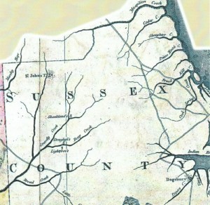
The Doe Bridge Association had its humble beginnings about seven-years ago when I developed the urge to learn more about the area surrounding Doe Bridge.  A visit to the State Archives turned up a colonial-period map that showed a road running southwest from Lewes and crossing a large stream north of Millsboro.

I acquired a large copy of an aerial photo from a government agency and immediately saw the remnants of a road, evident even through the canopy of trees. Then, I stumbled upon a copy of a 1795 map that also showed a road running across the area of the old mill and bridge.

sussex-map-1795
Sussex map 1795

I did say Doe Bridge, right? Why this should have been such an awakening, I’ll never know, for where there’s a bridge, there must be a road.

I also recalled hearing about a settlement possibly being located in that same area, before Millsboro was a town. Now I was intrigued and the subject created within me a desire to know more about the area that did not lessen with time.

Read more