
The Evidence Was Still There!
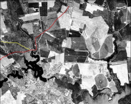
Clearly identifiable on the USDA aerial photo that I held in my hands, even through the treetop canopy, was a thin line that could only be the remnants of that old colonial road. It wound from Delaware 30, in almost perfect alignment with Doc Frame Road, turned in the woods, passed near the Revel house, and disappeared at the mill site.
The road reappeared on the west bank of the stream and was very evident on the photo as it made its way west toward present-day Patriot’s Way, across what in part is now Stockley Center, before emerging at the sharp curve just before Fox Run Road (Bark Pond Road on some maps).
It would then pass the old stage inn (the Vic Steele home of my youth) that sat on the rise at the intersection of Patriot’s Way and Fox Run Road, before disappearing to the southwest, any western connection obscured by the passage of time and development.
The Game’s Afoot
Armed with this information, I contacted Dick Carter of Millsboro and Ron Dodd of Georgetown, in the fall of 2002, and we made arrangements to meet one Sunday morning at a restaurant, in Millsboro. Along with a friend of mine from work, we four drove out to the mill site and walked and talked for over an hour. From the mill, we walked along the stream bank up to the site of an old cemetery, now known to contain Simon Kollock’s grave, and adjacent to the reputed site of the old Indian River Presbyterian Church. There again, we talked. They talked; I listened.
It was obvious why the mill was located along a waterway, but my curiosity was aroused by the presence of the cemetery and the mystery of an old church that had once stood in the general vicinity.
What other buildings might have once stood nearby?
Could this area have pre-dated Millsboro as a settlement of some type?
Some historians believe that may be the case:
“Millsboro generally marks its beginning with Elisha Dickerson’s construction in 1792 of the mill-dam across upper Indian River. In reality, however, its early history springs from a little settlement a short distance upstream which by 1792 had been flourishing for nearly a century and was destined to be known as Doebridge.”1
The cemetery and church sites are definitely upstream from the mill. But, were there any actual records of a settlement?
“The area around Indian River had been a hotly contested section between William Penn and the Calverts of Maryland. By the 1690s the river was the understood boundary between Penn’s Sussex and Somerset County, Maryland. Even so, both Penn and the Calverts were still scrambling to settle the upper reaches of Indian River. The settlement in the area which came to be known as Doebridge first enters the historical record in October 1693.”1
1 Doe Bridge Mill Brochure, Millsboro, Delaware, Millsboro Women’s Civic Club, and taken from “A Brief History of Doe Bridge Mill” by Richard Carter
NEXT TIME: More Connections
Doe Bridge Association Meeting
The next meeting of the Doe Bridge Association will be held on Sunday, March 4th at 1:30 PM, in the banquet room of the Millsboro Fire Company. Please check back for more details closer to the date.