
Millsboro By-Pass
In late November last year, I was contacted by a WBOC-TV reporter who asked for an interview concerning the proposed Millsboro By-Pass. I accepted and agreed to meet with him at Doe Bridge. Many visitors to this website may have already seen the article and the video. As I stated to the reporter in comments that did not make the final video cut (and I’m paraphrasing from memory), “I understand the need for a by-pass to alleviate the heavy traffic that is beating Millsboro’s infrastructure to dust, but I am likewise sympathetic with those property owners who will have to endure the shift in traffic to their backyards as the result of any by-pass. While I cannot speak for my friends, as I am not a spokesperson for them, my personal desire is to learn as much about the history of the Doe Bridge area as possible before nature or man takes that opportunity from us.”
Doe Bridge Association Roots
The little group I began a few years ago, with three friends, has grown, as new members have begun to show up regularly at our meetings. The group, which I dubbed the Doe Bridge Association, is made up of people from the area who are known to each other and who have a common interest in local history.
My interest in Doe Bridge dates back to my boyhood. Having grown up in Millsboro and played along the river banks, ponds and streams of the area, there was a natural inclination to revisit all of those places still vivid in my memory. But Doe Bridge had eluded my youthful escapades and now posed even more questions for me than it did those many years ago.
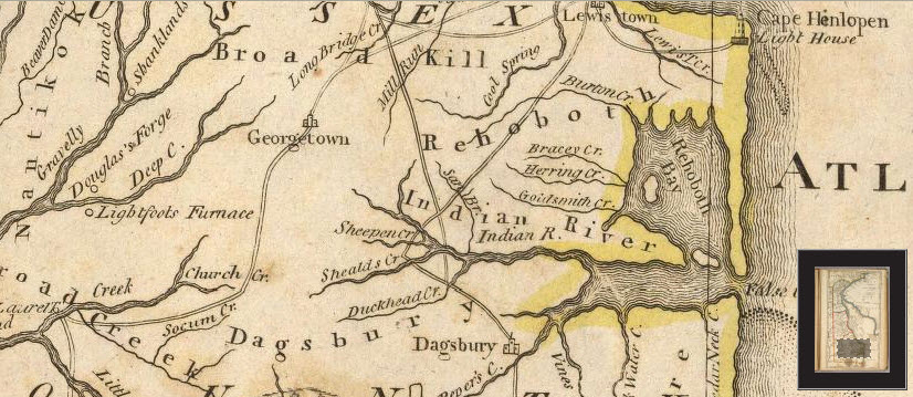
When I first began my research into the area around 2000, I gathered copies of maps wherever I could find them. On old maps from the 1700s and 1800s, a major road was evident from Lewes proceeding southwest toward Millsboro, passing it just to the north, and then crossing the headwaters of the Indian River at that point. That location? Doe Bridge.
I noticed the old colonial road from coastal Delaware Bay to Doe Bridge on a 1796 Doolittle map engraving that I found while researching at the Delaware State Archives.
Then I compared that road with the road between “Lewistown” and Doe Bridge on a 1814 Matthew Carey map –
Comparing those with this composite that I made from adjacent Dagsboro and Indian River Hundred maps from the Pomeroy & Beer’s Atlas of 1868, the road was seen to be prominent as late as this –

This was this very interesting and I believed that what I saw was an important avenue of commerce and communication which connected a bustling agri-industrial economic center of its day with an established Delaware Bay port in Lewes. So I went to the Sussex Conservation District in 2001, obtained information about the USDA aerial photography process, and then ordered a 24” x 24” aerial photo that included the Doe Bridge area. I can vividly remember my reaction the first time I looked at that map.
NEXT TIME: The Evidence Was Still There
Doe Bridge Association Meeting
The next meeting of the Doe Bridge Association will be held on Sunday, March 4th at 1:30 PM, in the banquet room of the Millsboro Fire Company. Please check back for more details closer to the date.